Apart from the Hunt, Quorn was well-known
for its spectacular floods. Fortunately modern engineering has solved
this dangerous inconvenience to a large extent. In this section you
can view photographs of the village under water and read about the
Great Flood of 1875 when a man lost his life in the grounds of White
Horse.
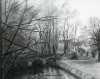
 |  | Floods 1932, near One Ash, Quorn
This photograph of floods in the Soar Valley was kindly submitted by Nick Miller from ...... cont.
 |
| | |
 | | Drawing of Buddon Brook/Quorn Memorial Gardens, late 1980s
An atmospheric drawing of Buddon Brook and part of the Memorial Gardens by Diane Ross ...... cont.
|
| | |
 | | Then and Now Floods in Quorn
The first photograph was taken in the early 1980s and shows Ruth Iley from Farnham Street ...... cont.
|
| | |
 | | The exceptional Quorn floods of 1875
Although Quorn had always flooded, July 1875 saw the worst floods that the village had ...... cont.
|
| | |
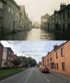 | | Leicester Road floods Then and Now
The older photograph is difficult to date, but probably 1930s. The view, taken from the ...... cont.
|
| | |
 | | Floods in Soar Road, Quorn
The first of these two photographs was taken in 1979 after the River Soar had flooded ...... cont.
|
| | |
 | | The Slabs footpath in flood Then and Now
The Slabs footpath runs between Quorn and Barrow to the north of Quorn Hall, near to the ...... cont.
|
| | |
 | | Terrific Gale Strikes Loughborough and Quorn, March 1947
Loughborough Echo, Friday, 21st March 1947
ROADS BLOCKED BY FALLEN ...... cont.
|
| | |
 | | Floods, Meeting Street, 1960
Before flood prevention measures were taken in Quorn, the village used to flood with ...... cont.
|
| | |
 | | Floods in Quorn, 1961
Before flood prevention measures, Quorn used to flood to a greater or lesser extent every ...... cont.
|
| | |
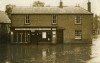
 | | Royal Oak, Quorn in the floods, early 1930s
This photograph was taken in the floods at Quorn Cross/Meeting Street, by the Royal Oak ...... cont.
|
| | |
 | | Soar Valley News, April 1977
The Soar Valley News was a four page, black and white community newspaper/newsletter type ...... cont.
|
| | |
| | A tragic accident during the Quorn floods of 1875
1875 saw some of the worst floods in Quorn for many years. The newspapers recorded the ...... cont.
|
| | |
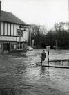
 | | Floods around the White Horse pub, Quorn, 1986
The first photograph was taken during the floods of 1986, looking up Meeting Street, ...... cont.
|
| | |
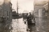
 | | Floods on Station Road, probably 1947
The gabled building behind the lorry is the White Horse pub, on the corner of Station ...... cont.
|
| | |
 | | Floods at Quorn Cross in the 1950s or 1960s.
Flooding at Quorn Cross was a regular occurrence until flood prevention measures were ...... cont.
|
| | |
 | | Quorn Cross in the floods
It is not certain in which year this photograph was taken, but it looks like the 1950s or ...... cont.
|
| | |
 | | Harry and Ada Yeomans - floods on Leicester Road in 1960
The top photograph was taken during floods in the 1960s and appeared in the Leicester ...... cont.
|
| | |
 | | Otter's Post Office and grocery store in the floods
This photograph shows Quorn Cross during some heavy flooding. Otter's took over from ...... cont.
|
| | |
 | | Mill House Inn, Leicester Road during floods in the 1920s
The Mill House Inn used to be on Leicester Road, abutting what are now Wright's factory ...... cont.
|
| | |
 | | Floods on Leicester Road, 1960s
This photograph is taken looking up towards the Cross on Leicester Road. Wakerley Court ...... cont.
|
| | |
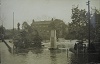
 | | Floods on Stafford Orchard, early 1970s
This view from the early 1970s is taken from what is now the Station Road car park, ...... cont.
|
| | |
 | | Floods on Station Road, early 1970s
These two pictures of Station Road during the floods, were taken by Richard Thompson, who ...... cont.
|
| | |
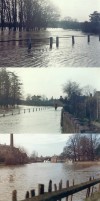
 | | Floods at Quorn Cross, early 1970s
These photographs were taken by Richard Thompson during floods in the early 1970s.
|
| | |
 | | Floods on Leicester Road, early 1970s
These pictures are taken at Quorn Cross, on Leicester Road in the early 1970s, showing ...... cont.
|
| | |
 | | Leicester Road floods in 1932
Marius Wright (1914 to 1980) was driving his Morgan through floods on Leicester Road in ...... cont.
|
| | |
 | | Flood 1960
Station Road under water in December 1960
|
| | |
 | | Boy Scouts' Narrow Escape - camp flooded in early morning hours.
Loughborough Monitor and Herald - August 10th 1922
The district around Quorn and ...... cont.
|
| | |
 | | Life goes on during the floods
This photograph is taken looking up Station Road towards the cross and the Royal Oak. Mr ...... cont.
|
| | |
 | | Floods in the Early 1980s
This photograph shows Ruth Iley from Farnham Street (in her twenties), standing outside ...... cont.
|
| | |
 | | Floods in the Early 1980s
Despite flood prevention measures, prolonged heavy rain in the 1980s still caused ...... cont.
|
| | |
| | Quorndon Parish Council, monthly meeting April 1963
Loughborough Monitor - 12th April 1963
Quorn Parish Council decided at its monthly ...... cont.
|
| | |
 | | Heavy flooding in the Loughborough District - 1960
Loughborough Echo - 9th December 1960
At Quorn on Saturday night a double-decker bus ...... cont.
|
| | |
 | | Flood of 1932
This is one of three photographs found in the Leicester Record Office showing the severe ...... cont.
|
| | |
 | | Flood of 1932
Although not of a good quality, Leicester Record Office has photographs of a severe flood ...... cont.
|
| | |
 | | Flood of 1932
1932 must have been a bad year for flooding. We found several photographs in the ...... cont.
|
| | |
| | Parish Council warned - River Soar may change course - 1953
Loughborough Monitor - 10th April 1953
Parish Council Meeting
In not many years ...... cont.
|
| | |
| | Quorn flood of 1901
Extract from Parish Magazine - January 1901
The floods which closed the old year and ...... cont.
|
| | |
| | Quorn and District floods of 1948
Loughborough Echo - 12th November 1948
SOAR VALLEY FLOODS
Many Roads ...... cont.
|
| | |
| | Quorn floods of 1882
Birmingham Daily Post - 6th June 1882
Floods in Leicestershire
During the past three ...... cont.
|
| | |
| | Quorn Floods in 1939
Loughborough Echo - 27th January 1939
The recent snow and rain seem likely to bring ...... cont.
|
| | |
| | Parish Council
Loughborough Monitor - 16th May 1969
Quorn Parish Council are becoming increasingly ...... cont.
|
| | |
 | | Quorn Floods 1977
Loughborough Echo - 4th March 1977
Quorn Cross, which is a well-known danger point ...... cont.
|
| | |
 | | Floods on Barrow Road
Taken in 1951, the slightly raised level (where the motorcyclist is) is the location of ...... cont.
|
| | |
| | The Floods of 1901
Extract from Parish Magazine, January 1901
The floods which closed the old year and ...... cont.
|
| | |
 | | Floods on Station Road 1920s
Judging by the clothes, this photograph was taken in the 1920s outside Facer's shop. One ...... cont.
|
| | |
 | | Floods follow the thaw 1962
Loughborough Echo - January 12th 1962
Photograph 1 shows a car in trouble on the road ...... cont.
|
| | |
 | | Leicester Road in flood 1933
Two similar images of Leicester Road in flood. Taken from the property to the left of the ...... cont.
|
| | |
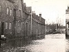 | | Shops on Leicester Road, Quorn, during floods
A photo looking towards Quorn Cross showing the Tea Shop on Leicester Road and the row of ...... cont.
|
| | |
 | | Floods on Loughborough Road, Quorn
Severe flooding on the Quorn to Loughborough road causes problems for traffic. c1918
|
| | |
| | Quorn Parish Council 1947
Loughborough Monitor - 9th January 1947
In response to complaints about flooding in ...... cont.
|
| | |
 | | After the snow came the floods
Loughborough Monitor - 20th March 1947
At Quorn, Mr A W Hincks, landlord of the "White ...... cont.
|
| | |
 | | Stream from Tom Long's Meadow, Quorn
Builders break into the culvert carrying the stream from Tom Long's Meadow into Quorn ...... cont.
|
| | |
| | The great flood at Quorn - July 21st 1875
Notes by C Murray Rumsey
A Mountsorrel Pepys
Discovery of old diary
Diaries can ...... cont.
|
| | |
 | | The Green in flood
Note the lock up to the left and Wright's factory in the distance. This view has been ...... cont.
|
| | |
 | | Children on School Lane causeway
Children on causeway looking from School Lane towards the river c1920s. The granite wall ...... cont.
|
| | |
 | | Floods on Station Road, Quorn 1922
Station Road flooded in August 1922. Note the railings of Black Green on the left. The ...... cont.
|
| | |
 | | Soar-side cottages on Soar Road
Built on a stone plinth, with steps probably to keep them above flood level, these ...... cont.
|
| | |
 | | River Soar
The river at Soar Road, Quorn about 1960. During the 1930's and 40's village children ...... cont.
|
| | |
 | | The Stafford Orchard in flood. 1930s
Floods in the Stafford Orchard. This photograph has been taken from where the existing ...... cont.
|
| | |
 | | Floods in Soar Road, Quorn 1930s
Pre-1940 floods in Soar Road. This is a view looking east towards Stoop Lane. The ...... cont.
|
| | |
 | | Floods at Quorn Cross and Station Road
Date unknown, however, there was substantial flooding in 1922 and 1932 which led to ...... cont.
|
| | |
 | | Floods in Station Road, Quorn c1900
c1900 Station Road under a considerable amount of water. The building gable on the left ...... cont.
|
| | |
 | | Floods on the Village Green in 1932
The single storey building to the right in the foreground housed the fire engine in 1908, ...... cont.
|
| | |
 | | The River Soar in flood c1900
This is a view facing east along Soar Road towards Santa Maria Lodge. The coal wharf ...... cont.
|
| | |
 | | The Slabs
The Quorn to Barrow Slabs footpath under water in the 1920s. 'Scotche Greene' or the ...... cont.
|
| | |
Total: 66 artefacts returned