|
|
|
Quorn Maps and Aerial Views
We have a number of maps, plans and aerial views of the village. In many of these it's interesting to note how the village has changed over the years, with buildings having been demolished, in particular the mills and associated buildings surrounding the centre of the village. In other areas the village has changed and expanded as land and property has been bought and sold, often by the aristocracy selling large holdings which have then been bought as much smaller areas by local people.
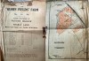 | | Sale of Quorn Fields Farm 1933
Quorn Fields Farm was situated down a long track off Barrow Road, now known as Flesh ...... cont.
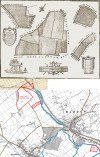
 | | | |  | | A story about Quorn Parish boundary by Barrow Bridge, from 1909
A STRANGE DIVERGENCE OF THE BOUNDARY BETWEEN THE TWO PARISHES OF QUORN AND ...... cont.
| | | |  | | Woodthorpe and Quorndon Parish Boundary Marker
This boundary marker was originally sited on the A6 Trunk Road to indicate the position ...... cont.
| | | | 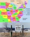 | | Quorn in Iowa, America, now known as Kingsley
Two brothers Fredrick and William Close went to the USA from England in 1876. They ...... cont.
| | | | 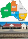 | | Quorn in Australia
Did you know that there is a Quorn in South Australia? This small township which is ...... cont.
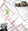
| | | |  | | Estate of Revd John Prior of Quorn, 1831
This plan was drawn up in 1831 to record the landholdings of the Revd John Prior from ...... cont.
| | | |  | | Warwick Avenue, Quorn
Warwick Avenue came into being in 1934, when Gambles, the builders, were building the ...... cont.
| | | | 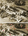 | | Aerial view of Wright's factory and surrounding area - approx 1952
This aerial photograph was taken in the early 1950s, as evidenced by the size of the lime ...... cont.
| | | |  | | 1864 Map of Quorn
The first Ordnance Survey maps which covered Quorn were produced in the 1880s. Prior to ...... cont.
| | | |  | | 1816 Map of Quorn
This rare map of early Quorn was extracted from a much larger map, which was commissioned ...... cont.
| | | |
Total: 46 artefacts returned over 5 pages
|
|
|
|