We have a number of maps, plans and aerial views of the village. In many of these it's interesting to note how the village has changed over the years, with buildings having been demolished, in particular the mills and associated buildings surrounding the centre of the village. In other areas the village has changed and expanded as land and property has been bought and sold, often by the aristocracy selling large holdings which have then been bought as much smaller areas by local people.
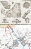
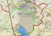 |  | Quorns Medieval Deer Park - Area
There was no settlement of Quorn (or Quorndon) when the Domesday Book was produced in ...... cont.
 |
| | |
 | | Quorns Medieval Deer Park - Evidence
There was no settlement of Quorn (or Quorndon) when the Domesday Book was produced in ...... cont.
|
| | |
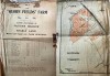 | | Sale of Quorn Fields Farm 1933
Quorn Fields Farm was situated down a long track off Barrow Road, now known as Flesh ...... cont.
|
| | |
 | | A story about Quorn Parish boundary by Barrow Bridge, from 1909
A STRANGE DIVERGENCE OF THE BOUNDARY BETWEEN THE TWO PARISHES OF QUORN AND ...... cont.
|
| | |
 | | Woodthorpe and Quorndon Parish Boundary Marker
This boundary marker was originally sited on the A6 Trunk Road to indicate the position ...... cont.
|
| | |
 | | Quorn in Iowa, America, now known as Kingsley
Two brothers Fredrick and William Close went to the USA from England in 1876. They ...... cont.
|
| | |
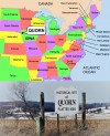
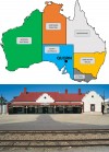 | | Quorn in Australia
Did you know that there is a Quorn in South Australia? This small township which is ...... cont.
|
| | |
 | | Estate of Revd John Prior of Quorn, 1831
This plan was drawn up in 1831 to record the landholdings of the Revd John Prior from ...... cont.
|
| | |
 | | Warwick Avenue, Quorn
Warwick Avenue came into being in 1934, when Gambles, the builders, were building the ...... cont.
|
| | |
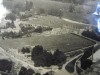
 | | Aerial view of Wright's factory and surrounding area - approx 1952
This aerial photograph was taken in the early 1950s, as evidenced by the size of the lime ...... cont.
|
| | |
 | | 1864 Map of Quorn
The first Ordnance Survey maps which covered Quorn were produced in the 1880s. Prior to ...... cont.
|
| | |
 | | 1816 Map of Quorn
This rare map of early Quorn was extracted from a much larger map, which was commissioned ...... cont.
|
| | |
 | | 1815 Map of Quorn
Before the first Ordnance Survey maps, (1880s for Quorn), maps were only made privately ...... cont.
|
| | |
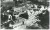
 | | Rawlins School, Quorn, aerial view, post 1938
This postcard must date from after 1938 as the Farnham Hall (old gym) is indicated as ...... cont.
|
| | |
 | | View over Wrights factory from the Church tower then and now
These photographs were taken from the top of the Church tower, looking towards Wrights ...... cont.
|
| | |
 | | View over Nursery Lane from the Church tower then and now
These photographs were taken from the top of the Church tower, looking towards Nursery ...... cont.
|
| | |
 | | View over Church Lane from the Church tower then and now
These photographs were taken from the top of the Church tower, looking towards Church ...... cont.
|
| | |
 | | View over Rawlins School from the Church tower then and now
These photographs were taken from the top of the Church tower, looking towards Rawlins ...... cont.
|
| | |
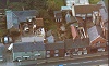
 | | Aerial view of Barrow Road and Howlett's Bus Station
Howlett's Bus Company was founded in Quorn by George Howlett in the early 1920s. The ...... cont.
|
| | |
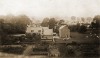
 | | Aerial view of Stafford Orchard c1950
A somewhat fuzzy but interesting view of Stafford Orchard before development. Note the ...... cont.
|
| | |
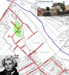
 | | Proposed housing development next to the Churchyard
The date of this plan is not certain, but it would appear that at some point there was a ...... cont.
|
| | |
 | | Priors Map 1779
John Prior was born in 1729 in Swithland, son of the steward of Sir John Danvers of ...... cont.
|
| | |
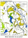 | | Quorn, Mountsorrel, Rothley Bypass Options
This document was used to set out the two options for the Quorn, Mountsorrel, Rothley ...... cont.
|
| | |
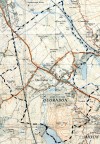 | | Map of Quorn, 1950s
This map was originally 2.5 inches to the mile. The team only had a portion of it, so ...... cont.
|
| | |
 | | 1921 Map
Portion of map showing the centre of the village.
|
| | |
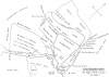
 | | Quorndon Map, North Field, 1752
A pre Enclosure Act map of Quorndon, The North Field (or Moor Field), in 1752. Area ...... cont.
|
| | |
 | | Quorndon Map, West Field, 1752
A pre Enclosure Act map of Quorndon, The West Field, in 1752. Area stated as 334 acres.
|
| | |
 | | Quorndon Map, South Field, 1752
A pre Enclosure Act map of Quorndon, The South Field, in 1752. Area stated as 457 acres.
|
| | |
 | | Aerial View c1950
The open area lower-right is now the Sanders Road area. The Stafford Orchard can be seen ...... cont.
|
| | |
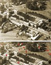
 | | Aerial photograph of Wright's Mill
Much has changed since this image was taken, although much also remains. Many of the ...... cont.
|
| | |
 | | Camm Map 1838
Drawn by Mr Joseph Camm and presented by his son James Camm in 1908.
Joseph Camm was ...... cont.
|
| | |
 | | Mountsorrel Quarry - then and now 1972 and 1995
An aerial view of what was Buddon Wood, now mostly removed by quarrying activities ...... cont.
|
| | |
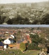
 | | Aerial view of Quorn village centre
Taken c1994 on a winter day early in the evening, this view shows the Stafford Orchard ...... cont.
|
| | |
 | | Aerial view of Stafford Orchard
Taken from a hot air balloon in the mid 1990s. The old Primary School can be seen ...... cont.
|
| | |
 | | Aerial View of Station Road, Quorn and St. Bartholomew's Church
Photograph taken in 1994.
|
| | |
 | | Aerial view of Station Road, Quorn
Taken in 1994. This predates the developments in the grounds of the Conservative Club and ...... cont.
|
| | |
 | | Aerial view of Station Road
Taken in 1994. Lower-left is the corner of the Stafford Orchard. St. Bartholomew's church ...... cont.
|
| | |
 | | Aerial view of Tom Long's Meadow 1991
Plenty of change has happened since this photograph was taken in 1991.The Quorndon Fox is ...... cont.
|
| | |
 | | Aerial view of The Stafford Orchard 1994
Taken in 1994. Station Road is behind the line of trees.
|
| | |
 | | Aerial view of The Stafford Orchard 1994
Wright's Mill can be seen clearly upper-centre. The mill chimney still stands in this ...... cont.
|
| | |
 | | Aerial view of St. Bartholomew's Church 1994
Photographed from above the Stafford Orchard in 1994. Rawlins can be seen upper-right. ...... cont.
|
| | |
 | | St. Bartholomew's Church and Station Road
Taken in 1994. The Mill is still intact before conversion into flats and the mill chimney ...... cont.
|
| | |
 | | Aerial view of Quorn Park
Mountsorrel Quarry and Swithland Reservoir are visible also. Quorn Park is in the ...... cont.
|
| | |
 | | Postcard of Rawlins from the Church tower
This photograph was taken from the top of the Church tower, looking towards Rawlins, ...... cont.
|
| | |
 | | Aerial view of centre of Quorn Village c1994
A good aerial view of the centre of the village. The shops on Station Road, the parish ...... cont.
|
| | |
 | | Aerial view of the High Street, Quorn 1990s
The building centre-right fronting the road with the gable end is the old Bull's Head. ...... cont.
|
| | |
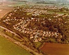 | | Aerial view of north west end of Quorn 1980s
Streets visible include Toller Road and Chestnut Close, plus the Great Central Railway in ...... cont.
|
| | |
 | | Aerial view of Stafford Orchard, Quorn 1990s
Taken from a hot air balloon in the mid 1990s. The Old Primary School can be seen ...... cont.
|
| | |
Total: 48 artefacts returned