|
||||||||||||||||||||||||||||||||||||||||||||||||||||||||||||||||||||||||||||||||||||||||||||||||||||||||||||||||||||||||||||||||||||||||||||||||||||||||||||||||||||||||||||||||||||||||||||||
Thursday 16th July 2026 |
||||||||||||||||||||||||||||||||||||||||||||||||||||||||||||||||||||||||||||||||||||||||||||||||||||||||||||||||||||||||||||||||||||||||||||||||||||||||||||||||||||||||||||||||||||||||||||||
|
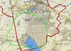
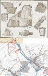
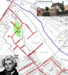
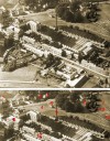
Quorn Maps and Aerial ViewsWe have a number of maps, plans and aerial views of the village. In many of these it's interesting to note how the village has changed over the years, with buildings having been demolished, in particular the mills and associated buildings surrounding the centre of the village. In other areas the village has changed and expanded as land and property has been bought and sold, often by the aristocracy selling large holdings which have then been bought as much smaller areas by local people.
page 1 | page 2 | page 3 | page 4 | page 5 | show me: 3 | 5 | 10 | 25 | 50 | 100 | artefacts per page
|
|
||||||||||||||||||||||||||||||||||||||||||||||||||||||||||||||||||||||||||||||||||||||||||||||||||||||||||||||||||||||||||||||||||||||||||||||||||||||||||||||||||||||||||||||||||||||||||||